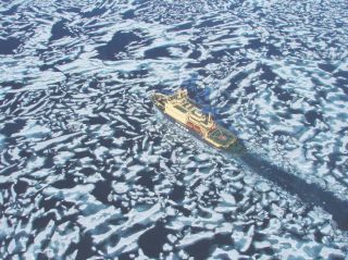
I-spied: The Russian icebreaker-cruise ship Kapitan Klebnikov seen from one of its helicopters plowing through sea ice north of
Weather in Japan: from balmy to barmy
By Mark Brazil | Feb 8, 2014
The division of Japan into distinct climatic zones means that anyone traveling around the country will normally encounter quite predictable demands in terms of clothing requirements; while for those in any one area the local weather forecast will be correct more often than not.Only spring in Japan truly merits the meteorological descriptor “changeable,” what with its variable wind strengths and directions before warm air masses advancing from the south begin to dominate over weakening cold polar air from the north. Then, at the end of spring, the rainy season begins and tracks up the country, hot on the heels of the cherry-blossom front.
Those spring winds can be powerful. The strongest sustained wind recorded in Japan (72.5 meters/second) was on April 5, 1942 on Mount Fuji, while the strongest recorded gust registered 91 m/s, also on Mount Fuji, but on Sept. 25, 1966.
As tropical southerly air pushes gradually northward, summer begins. A “west-low, east-high” pressure situation predominates over most of Honshu and southern Japan as we experience the rainy season (tsuyu) in June and early July. It is widely reported, by travel guides and the news media alike, that Hokkaido has no rainy season — something which, as a long-time Hokkaido resident, has always struck me as odd because just after it’s declared to be finished in northern Honshu, we invariably have increased rainfall here!
Following the rainy season, a period of more settled fair weather ensues with reduced precipitation before, in September, a second rainfall peak (shurin), when considerable rain falls in conjunction with typhoons.
In fall, from October onward in the north, polar air once again flows southward, bringing with it lower temperatures, although eastward-moving high-pressure areas bring beautiful autumnal days well-suited to viewing the splendor of the season’s foliage. By December, a “west-high, east-low” pressure situation becomes established — exactly the opposite of summer — such that cold dry air moves down off the continent from the northwest, resulting in thick clouds and heavy snow as, at last, winter sets in.
And when winter sets in, it can do so with a vengeance. Describing depth of snow is tricky, as it accumulates then compacts then accumulates more with each new fall, but the deepest fresh snow on record was 11.82 meters thick on Feb. 14, 1927 on 1,377-meter Mount Ibuki that straddles Shiga and Gifu prefectures on the eastern side of Lake Biwa.
Few other areas on Earth experience such a combination of tropical heat and humidity in summer and considerable depths of snow in winter, while having a basically predictable climatic system.
The next time you are tempted to complain about the weather in Japan, remember those sorry Britons bookending the other side of Eurasia beneath a low lid of cloud, suffering snow in May, hail in June, gray skies and rain in every month of the year including July, and — if they’re lucky — being treated to a little sunshine in August ahead of the leaves turning briefly yellow then dull brown.
That our seasons are changing is evident to anyone who has spent time out of doors over a number of decades, and some of those changes are indeed dramatic.
Turning again (as in this column last month) to the renowned English Japanologist Basil Hall Chamberlain, and his marvelous 1890 volume “Things Japanese,” we find him noting there how the typhoon season was from July to October, with the most severe of these tropical cyclones in August and September and altogether just four to five a year, with Tokyo hit by only one or two.
We can be sure to experience typhoons again this year, though how many is anyone’s guess as yet. Typhoons spawn over warmer regions of the Pacific Ocean well to the south of Japan as early as May, but strike much more frequently as summer gives way to autumn.
Daily weather maps screened on television news programs show how the dense spirals of terrifying winds and lashing rains curve northward toward the archipelago.
Some strike Kyushu, some veer on a more westerly course to Taiwan, the Korean Peninsula or continental China, but most curve north then east, battering at the coasts of Kyushu, Shikoku and Honshu, bringing with them tree-flattening gusts of wind and deluges of falling water.
The first autumnal typhoon I experienced was in 1983 — and it came as a shock, because I’d never witnessed anything like it. However, the storm’s natural ferocity was exhilarating, so I donned shorts, a T-shirt and sandals and was soon soaked and wading calf-deep in flood water down a street in Zushi, Kanagawa Prefecture, that was normally several meters above the water level in the local river.
The rain fell so fast and in such abundance that the river had risen almost instantly, flooded its banks and then the roads. Through the noise of the rain and wind I heard a strange metallic drum roll. When I realized what was causing it, I was stunned. The immense pressure of water in the storm drains beneath the road was pushing up the manhole covers, lifting them in their sockets and setting them rattling against their frames.
These days we can expect five times as many typhoons as Chamberlain noted, and as Minoru Matsutani wrote in The Japan Times on Nov. 2, 2013, “this is the year of the typhoon” — with 28 tallied by the end of October. Until August, 2013 had been on track to be an average year by modern standards, with 15 typhoons — though that was three times as many as Chamberlain would have considered average. Then, the unusually hot months of September and October spawned many more than expected. The storm of Oct. 16, 2013 (Typhoon Wipha) was ranked the strongest for 10 years in the Kanto region, and with the last two typhoons of the year in November, 2013 ended with a record-breaking total of 31 typhoons — way more than the previous year’s 25 or the annual average of 25.6 from 1981 to 2010, and vastly exceeding Chamberlain’s expectations.
Will we see another record in 2014? We know when we can expect them, just not how many will come. Only time will tell.
That first typhoon I witnessed, back in 1983, was as nothing compared with Japan’s worst. That sorry accolade goes to the Isewan Typhoon (Super Typhoon Vera) which slammed into southeastern Japan on Sept. 26, 1959 with wind speeds of 257 kph.
After making landfall in Wakayama Prefecture, Vera barreled northeast across Honshu leaving a trail of death, injury, destruction and flooding. Altogether, 5,098 people were killed, 401 were missing presumed dead, 38,921 were injured — and some 1.5 million were left homeless and prone to epidemics. As well, roads, railways, sea walls and agricultural land were destroyed or ruined.
Anyone who hiked to the 3,776-meter summit of Mount Fuji between the 1960s and 1990s would have seen one of the lasting legacies of that superstorm. To help provide advance warning of such events in the future, the Mount Fuji Radar System was built in 1964 and became the world’s highest weather radar, capable of observing major weather phenomena, such as typhoons, hundreds of kilometers away.
I recall tracking a fox on lingering snow past that weather station in early summer 1983, little realizing then that building’s significance or its link to such a disaster. Ultimately superseded by weather satellites, the station was decommissioned in 1999 and two years later its dome and radar dish were relocated to a museum in Fujiyoshida, Yamanashi Prefecture.
Meanwhile, despite being somewhat less powerful, the Makurazaki Typhoon still rates as one of the three worst in Japan’s history — though it was perhaps the most psychologically damaging as it struck on Sept. 17, 1945, just over a month after the Hiroshima and Nagasaki atom bombs. Makurazaki killed some 2,500 people and left another 1,283 missing and presumed dead — while more than 2,000 of the fatalities were in Hiroshima, survivors of that earlier hell.
One extreme weather event that I have not yet witnessed, and pray I never do, is the tornado. Japan’s annual tally is as nothing compared with the 1,300 recorded on average in North America, but even with an average of 17 a year between 1991 and 2006, due to Japan’s much smaller land area that’s equivalent to a third of all North America’s.
Tornadoes have struck widely in Japan, from the Yaeyama Islands in the southwest of Okinawa Prefecture, to Hokkaido’s easternmost Nemuro Peninsula and its (and Japan’s) northernmost city of Wakkanai to the Kanto plain and the Izu Islands offshore to the south. And, with anywhere between 10 and 37 a year since 2001, we are likely to hear news of further tornadoes, too, in 2014.
While Japan’s climate may be fairly predictable, all we can be really sure of is that there will be some surprises ahead — but then if there weren’t, it would be a very strange year indeed.

